|
The map
|
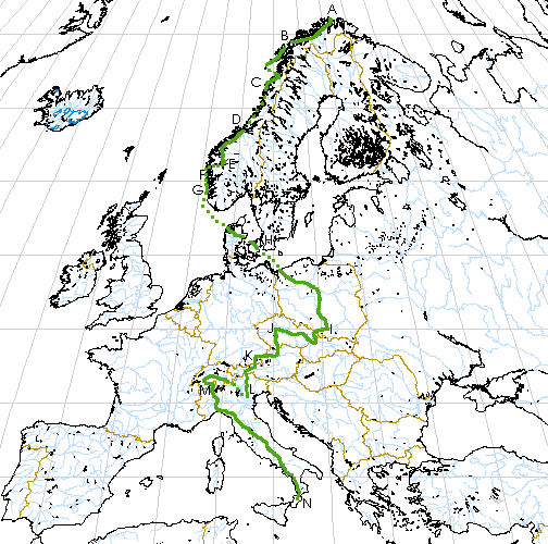
The map above shows my approximate route (there are some problems with
this map: see below). The solid green line corresponds to actual
cycling; the dotted green line indicates places where I used other
forms of transport. Here is a key to the labels on the map:
- A: Nordkapp, Norway: the beginning of my trip, on June 28, 1999.
- B: Vesteralen Islands, Norway (600km): I meet Berni.
- C: Mosjřen, Norway (1250km): cold and sick, I take the train with Berni
to Trondheim.
- D: Trondheim, Norway: Rosalba joins me on July 12.
- E: Sognefjell, Norway (1800km): double tire failure; we take bus and ferry to Bergen.
- F: Bergen, Norway.
- G: Stavanger, Norway (1900km): ferry to Hanstholm, Denmark on July 22.
- H: Copenhagen, Denmark (2300km): overnight ferry to Swinoujscie, Poland on
July 29-30.
- I: Krakow, Poland (3250km).
- J: Prague, Czech Republic (3850km): Rosalba leaves on August 22.
I head on alone.
- K: Rosenheim, Germany (4350km): I visit Berni on August 25.
- L: Abano Terme, Italy (4900km): Tommaso joins me on August 30. Train to
Passo Bernina, Switzerland.
- M: Domodossola, Italy (5450km): Tommaso leaves on September 6.
- N: Serra San Bruno, Italy (7030km): arrive home on September 15.
This map is based on one generated by the Xerox PARC map server. The
projection is a sinusoidal projection in which the linear scale along
the parallels and the central meridian is correct.
There are some problems with this map:
-
The borders for several countries in eastern Europe and the former
Soviet Union are incorrect, because the data used by Xerox in its map
server dates from 1985-1990.
-
The meridian grid lines are centered on the center of the map, and are
not whole degrees of longitude from Greenwich. This strangeness is
due to the simple way the coordinate system rotation was implemented
in Xerox's map server.
-
My labeling is only approximate: I manually tried to correlate places
on a paper map of Europe with points on the image returned by the map
server.
Nonetheless, this was the best free map I could find online at the
time of this writing (1999).